
Discover more than four thousand kilometers of walking paths from Budapest to Santiago de Compostela, to the ocean
“After years of work our dream became true, we connected Budapest (Aquincum, the eastern border of the Roman Empire, the limes Pannonicus ) with Santiago de Compostela and the end of the world (Finisterre) in a single journey. We have availed ourselves of the collaboration of the associations with which we’ve been exchanging information for years.” (Andrea Vitiello).
Today you can leave on foot or by bike from Budapest and get to Santiago crossing Italy. There are many paths available: via Pannonia, Jakobova Pot, Via Flavia, Via Postumia, Via Della Costa Ligure, Voie Aurelienne, Via Tolosana, Camino Aragones, and Camino Frances. This long itinerary, which stretches along 5 nations and over 4000 km, passes through 15 UNESCO sites.

4000 km on foot from Budapest to the ocean
Traveling this long itinerary is not so hard. The signs that mark the path is represented by the yellow arrow or the stylized shell, symbol of the jacobean paths. As for finding a place to stay instead, travelers can request us GPS tracks for safety and we will provide them with an accommodation list.
The first person to complete the whole trip was a Taiwanese girl, Hazel Chang. We are convinced that this journey can be a wonderful experience to overcome the great differences between these countries. In the meantime, we are working to improve every aspect, sign and welcome in the first place.

A dream through history
Everything started from a dream. “In a few years, only with voluntary work, we carried out this great project”, says Andrea Vitiello. Now, thanks to the large network of Associations, you can get to know the beautiful Europe. Fortunately, you’ll have the chance to do that through itineraries designed to be safe and out of the busy contexts. Besides, this path strongly promotes the rebirth of the Homo Viator, bearer of knowledge and culture. I believe that the movement of individuals and the cultural and experiential exchange is fundamental to break down the mental barriers in our society. Only by creating a European feeling we could see a better Europe. And what better way to discover the beauties we have meter after meter?
Via Pannonia

The Hungarian route is 415 km long and has 16 stages. Departing from Budapest, winding on a hilly track, it passes the castles of Csokako and Varpalota. Then, it arrives at Lake Balaton, the sea of Hungary. The path, which reaches a maximum altitude of 476 m, ends at the Slovenian border, near the village of Nemesnep.

Jakobova Pot
The Slovenian path, measuring 403 km and covering 20 stages, is shaped like the cross of Sant’Andrea. The two arms intersect in Ljubljana. one branch goes from the Croatian to the Austrian border, the other from the Hungarian border to Trieste. The latter will be used to continue the journey from Budapest. The route, which starts in Lenti (Slovenia), is mostly hilly and measures a maximum altitude of 851 meters. Ormoz, Ptuj, Kamnik, Ljubljana, Predjama Castle are some of the characteristic villages crossed by the route.

Via Flavia
This route measures 113 km, considering Muggia as a starting point, while from Trieste to Aquileia is 83 km. In addition to the beautiful Trieste, where the Slovenian path ends, the most interesting sites are the Castle of Miramare, Duino, Grado, and Aquileia. The stages of the route, 232 meters of altitude, in this case, are 4.

Via Postumia
This route counts 42 stages and measures 930 km, going on from Aquileia to Genoa. The first 600 km are on the plain, then you climb the hills of the Overseas Pavia. Finally you pass the Apennines at the Passo Della Bochetta, with its 830 meters of altitude. The sites worthy to be visited are many, let’s discover them region by region:
- Friuli (Aquileia/Palmanova)
- Veneto (Concordia Sagittaria,Oderzo,Treviso,Castelfranco Veneto, Cittadella, Piazzola sul Brenta, Vicenza, Lonigo, Verona, Peschiera del Garda)
- Lombardia (Ponti sul Mincio, Monzambano,Volta Mantovana, Le Grazie, Mantova, Sabbioneta, Casalmaggiore, Cremona, Cigognola, Voghera)
- Emilia (Piacenza,Corano,Ziano Piacentino)
- Piemonte (Libarna,Gavi)
- Liguria (Genova).
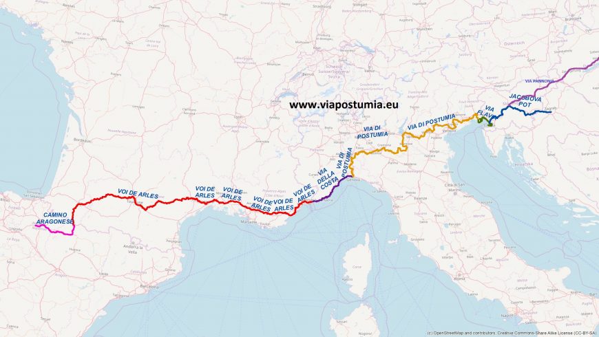

Via Della Costa Ligure
This route is 346 km long, even if in our route from Genoa to Menton it is 207 km long. After a first part on the waterfront, the hilly landscape takes over, exactly after Vado Ligure. This journey of 7 stages represents both a junction for the journeys towards Santiago de Compostela and the Via Francigena, crossed in Sarzana. Some of the most interesting sites are Genoa, Arenzano, Cogoleto, Varazze, Albissola, Vado Ligure, Spotorno, Noli, Varigotti. Other sites are Loano, Albenga, Alassio, Cervo, Civezza, Lingueglietta, Castellaro, Taggia, Sanremo, Bordighera, Ventimiglia.

Voie Aurelienne and Via Tosolana
These two paths, both marked as GR653, measure 1176 km and include 47 stages. The highest altitude is 1176 meters at the Col du Somport in the Pyrenees. Some interesting sites are Mandelieu la Napoule, Saint Raphael, Saint Maximim la Sainte Baume and Aix en Provence. Then, we go on with Salon de Provence, Arles, Saint Gilles, Vauvert, Montpellier, Saint Guilheme le desert, Toulouse, Auch, Oloron Saint Marie.

Camino Aragones, Camino Frances, Camino Fisterrano
The Aragonese route stretches 164 km from the Col du Somport to Puente la Reina, where it enters the Camino Frances. From the pass to Santiago de Compostela are 858 km. Among the 38 stages of the route, Jaca, Sanguesa, and Puente la Reina are the most popular. The most famous path in the world goes on towards Santiago de Compostela, touching the major sites of Burgos, Leon, Astorga. Once in Santiago, the path continues to the ocean. Once you reach Hospital, you will find the junction that allows you to choose which path to follow. The choice is between Fisterrano or Muxiano (at a distance of 28 km from each other).

This project, this dream, has still much to give. Collaborations with Croatian and Romanian Associations are active, and it is not excluded, finding the right connections, an extension of the network.
Have you also traveled a part of this long journey? What has the journey meant for you? Share your experience by commenting on the article!
Cover image: photo on Unsplash


